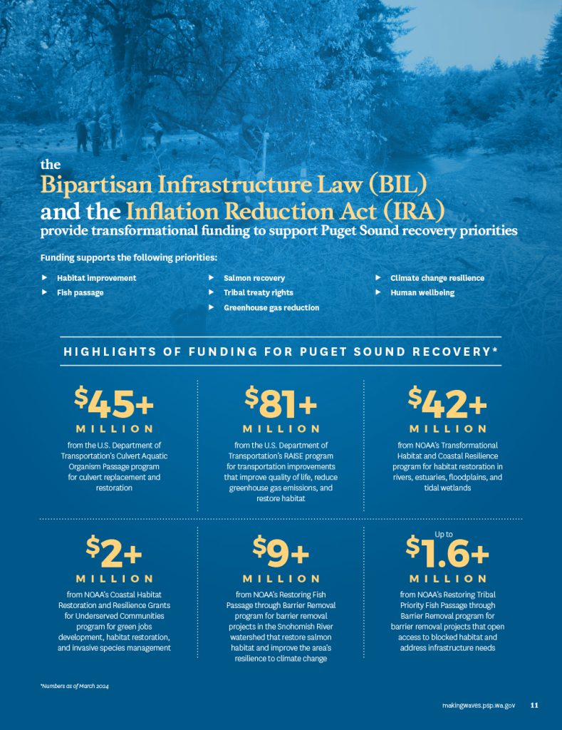
BIL and IRA funding also augments ongoing grant programs that support Puget Sound recovery
An additional $89 million above annual appropriations, over five years, for the Puget Sound Geographic Program, which supports the following:
- Maximum funding for the Strategic Initiatives of the Puget Sound National Estuary Program, which focus on stormwater, habitat, and shellfish
- Two new grant programs that address priority issues related to Puget Sound recovery
- The Climate Resilient Riparian Systems program supports voluntary protection and restoration of riparian habitat in Puget Sound watersheds
- The Ensuring Environmental Justice, Human Wellbeing, and Ecosystem Recovery in Puget Sound program advances environmental justice by directing resources and benefits to overburdened and underserved communities
- The Climate Resilient Riparian Systems program supports voluntary protection and restoration of riparian habitat in Puget Sound watersheds
- The Puget Sound Partnership’s Strategic Funding Team, a new effort that helps partners obtain funding for Puget Sound ecosystem recovery and salmon recovery projects
An additional $172 million above annual appropriations, over five years, for the Pacific Coastal Salmon Recovery Fund (PCSRF), a program devoted to reversing the decline of West Coast salmon. PCSRF funding supports projects throughout Washington state that fulfill Tribal treaty fishing rights, protect and restore salmon habitat, enhance fish passage, improve coordination and planning, and collect data and measure progress.
$6.7 million from the National Coastal Resilience Fund for projects that promote habitat restoration, climate change resilience, and capacity to address infrastructure improvement
$2+ million from the America the Beautiful Challenge to support Tribal treaty rights and address invasive species
Highlights of BIL- and IRA-funded Puget Sound recovery projects
NOAA Transformational Habitat Restoration and Coastal Resilience – Lower South Fork Nooksack Chinook Recovery 2023-2025
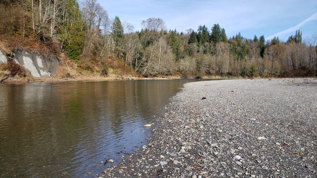
The Nooksack Indian Tribe will restore habitat to support salmon and steelhead in the South Fork Nooksack River. Declining populations of Chinook salmon and other species have had significant impacts on the Tribe’s cultural, subsistence, and commercial fisheries. By increasing habitat complexity and increasing the number of pools in the region to address summer flows, this work will support multiple life stages of salmon, enhance their resilience to climate change, and increase opportunities for Tribal uses.
NOAA Transformational Habitat Restoration and Coastal Resilience – Transformational Chinook Recovery in South Whidbey Basin Watersheds
The Washington State Department of Fish and Wildlife (WDFW) will restore habitat on a landscape scale within the South Whidbey Basin of Puget Sound. The Whidbey Basin contains Puget Sound’s three biggest salmon-producing rivers and nearly 70 percent of its remaining tidal wetlands, which salmon and steelhead rely on for spawning and rearing habitat. This work will significantly contribute to increasing estuary habitat for the recovery of threatened Puget Sound Chinook salmon and steelhead. The work will also benefit endangered Southern Resident killer whales. WDFW will partner with Tribes, local governments, and nonprofits on projects that will do the following:
- improve instream, floodplain, and estuary habitat;
- restore riparian buffers;
- create high-value riparian forests;
- increase agricultural resilience to climate change;
- remove creosote-soaked pilings;
- remove riverbank armoring;
- improve water quality and quantity; and
- engage with local communities.
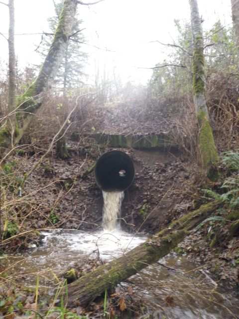
U.S. Department of Transportation Culvert Aquatic Organism Passage program – Chicken Coop Creek Culvert Restoration
Chicken Coop Creek is a small (12-feet-wide in its lower reaches) tributary to Sequim Bay in Clallam County. Historically, the stream provided about four miles of habitat for coho, steelhead, and cutthroat. Between river miles (RM) 0.1 and 0.3, three road culverts obstruct fish passage. Two culverts—at East Sequim Bay Road and Highway 101—are partial barriers, and the culvert on Old Blyn Highway/Olympic Discovery Trail at RM 0.2 is a complete barrier. In 2024, the Washington State Department of Transportation is replacing the Highway 101 culvert with a fish-passable bridge. The U.S. Department of Transportation has awarded the Jamestown S’Klallam Tribe $4.2 million to design and implement fish-passable culvert replacement projects at Old Blyn Highway and East Sequim Bay Road. The Tribe is collaborating with the North Olympic Salmon Coalition to perform the work, and the partners are striving to complete the project in 2026.
U.S. Department of Transportation Culvert Aquatic Organism Passage program – Springbrook Creek Fish Passage Restoration
Springbrook Creek is a designated critical habitat for Puget Sound steelhead, a threatened species under the Endangered Species Act. The existing culvert under Fletcher Bay Road is the first and most critical barrier for steelhead and other salmonids between the Puget Sound and the upper reaches of Springbrook Creek. The Springbrook Creek Fish Passage Restoration Project will replace the existing culvert with a three-sided concrete bridge culvert with natural bottom, and it will remove the eight concrete weirs and restore the degraded stream channel to increase salmonid access to the watershed, improving the delivery of sediment and wood to the Springbrook estuary.
The Springbrook Creek Fish Passage Restoration Project is a direct result of work completed by the Springbrook Creek Watershed Assessment (SCWA 2018), a multiyear, multi-partner effort led by Bainbridge Island Land Trust and Wild Fish Conservancy, with strong collaborative involvement by the City of Bainbridge Island, the Bainbridge Island Watershed Council, Washington State Department of Fish and Wildlife, and the Washington State Department of Ecology. The work was performed by numerous technical experts and more than 50 landowners were involved in the development of the Watershed Assessment.
“The Springbrook Creek Fish Passage Restoration Project is immensely important to help restore salmon and other critical habitats. Currently, there are 3.6 miles of inaccessible salmon spawning and rearing habitat beyond the culvert. The $2.6M in grant funding from the U.S. Department of Transportation’s Federal Highway Administration Culvert Aquatic Organism Passage Program is vital for the City of Bainbridge Island in supporting this project.” — City of Bainbridge Island Mayor Joe Deets.
U.S. Department of Transportation RAISE grant – Planning for low-emission neighborhoods
This planning project will develop a funding and implementation plan for “Low-Emission Neighborhoods” across the City of Seattle. Using a data-driven, community- centered approach and engaging industry partners, zero-and low-emission transportation projects and programs will be defined for at least three low-emission neighborhoods. The project will consider climate change and environmental justice, by reducing transportation-related air pollution and greenhouse gas emissions by recommending regulatory and infrastructure measures for reducing vehicle-miles traveled and increasing low- and zero-emission transportation trips in areas where the city has completed substantial transit investments. The project targets a known and documented safety problem by protecting non-motorized travelers and communities from safety risks through specific activities identified in the U.S. Department of Transportation’s National Roadway Safety Strategy plan for pedestrians and bicyclists. The project will also increase affordable transportation choices and mobility through improving and expanding active transportation facilities. In addition, the project will reduce construction and maintenance burdens through efficient and well-integrated design that promotes lighter weight vehicles, biking, and walking.
“Transportation emissions are Seattle’s number one source of climate pollution, and reducing the impact in our neighborhoods will improve the overall health of our residents as we fight climate change. As called for in our Seattle Transportation and Climate Justice Executive Order, Low-Emissions Neighborhoods recognize the connection between transportation, climate, and community and work to address these aspects collectively.” — Seattle Mayor Bruce Harrell.
National Fish and Wildlife Foundation National Coastal Resilience Fund – Issaquah Creek Instream Restoration at Lake Sammamish State Park
The Mountains to Sound Greenway Trust and the Washington State Parks and Recreation Commission are partnering to study instream habitat and natural process improvements along the lower 6,000 feet of Issaquah Creek that flows through Lake Sammamish State Park. With 1.3 million annual visitors to the State Park, this project will be highly visible with tremendous community outreach and education opportunity. When completed (phase 1 construction is currently planned for summer of 2025), along with other efforts underway by State Parks and the City of Issaquah, it will finish nearly all restoration that is proposed in the lower reach of Issaquah Creek in the 2005 Chinook Salmon Conservation Plan (WRIA 8, 2005) and the 2017 update to the Plan (WRIA 8, 2017).
This project aims to improve juvenile Chinook salmon rearing habitat by re-engaging the floodplain; inserting large woody material to create pools, reduce and redirect water flow, and increase cooler pockets of water; reforest riparian areas to increase shade, nutrients, and food and vegetative matter; and improve habitat conditions for other salmon species like coho and sockeye.
“The Issaquah Creek project exemplifies two decades of community work that seeks ecological resilience within a vibrant urban area, forging a shared vision of habitat restoration to bring healthy vital streams back to the animals and people that need them. This collaboration of regional agencies, Tribal communities, nonprofits, and community groups have come together to revive salmon habitat in a culturally cherished region. Rooted in common ground and fortified by both federal and local support, this endeavor symbolizes the resolute spirit and positive impact of partnerships within the Mountains to Sound Greenway National Heritage Area.” — Mountains to Sound Greenway Trust Executive Director Jon Hoekstra
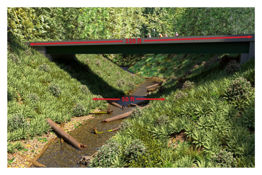
U.S. Department of Transportation Culvert Aquatic Organism Passage program – Green Cove Creek Fish Barrier Removal
Three years ago, Thurston County inspectors identified a culvert in critical condition and at risk of collapse beneath Country Club Rd NW. Such a collapse would obstruct the flow of Green Cove Creek, causing environmental damage by sending sediment downstream. Water would accumulate upstream, potentially compromising road safety, utilities, and emergency access. An emergency repair was completed in November 2021 to maintain streamflow continuity and protect public safety. Thurston County Public Works is now moving forward with a permanent solution. This $9 million investment will fund the construction of a 150-foot span bridge, replacing the temporary culvert. This project is crucial for restoring fish passage and preserving environmental and community wellbeing in the Green Cove Creek area.
“This is the third-largest project in total dollars that Thurston County Public Works has ever constructed, reflective of the broader context of escalating infrastructure costs. The allocation of $3 million in federal funding significantly offsets the financial impact on Thurston County residents and underscores the national importance of preserving the Green Cove Creek watershed for salmon recovery initiatives.” — Marcus Storvick, PE, civil engineer, Thurston County Public Works
NOAA’s Coastal Habitat Restoration and Resilience Grants for Underserved Communities – Building Capacity for the Nisqually Indian Tribe to Integrate Habitat Restoration into the Interstate 5 Redesign Planning Process to Reduce Flood Risk and Increase Climate Resilience
While the Washington State Department of Transportation has launched the I-5 Marvin Rd to Mounts Rd Planning Project to protect the portion of I-5 crossing the Nisqually River Delta, the Nisqually Indian Tribe is partnering with Long Live the Kings and others to seek more comprehensive nature-based solutions to improve resilience to extreme weather events, restore ecological function, and expand vital habitat availability to salmon and other wildlife. NOAA’s 2022 Coastal Habitat Restoration and Resilience Grant to Long Live the Kings is helping the Tribe engage with key public and private stakeholders throughout the Nisqually River Delta as it develops an early-stage conceptual design for a resilient delta. This project is a major priority for the Nisqually Indian Tribe to ensure Tribal goals for nature-based solutions within the Nisqually River Delta are included as part of broader planning efforts for the region.
“The Tribe’s vision for restoration of vital habitat to the culturally and ecologically significant salmon runs in the Nisqually Estuary goes hand-in-hand with Long Live the Kings’ mission. We are grateful for the opportunity the NOAA Coastal Habitat Restoration funding has allowed for Long Live the Kings to provide capacity resources to the Tribe to progress toward their goals in the restoration of the Nisqually River Delta.” — Keith Estes, project manager, Long Live the Kings