How the Salish Sea Nearshore Programmatic and the Partnership's Nearshore Credits Program drive restoration throughout Puget Sound
At the far end of Hood Canal, near Belfair, Mendy Harlow and Andy Hokit looked out over Union River flowing into Lynch Cove. They discussed a levee removal project that’s slated to start this summer.
It was a sunny, cool day at the beginning of March; redwing blackbirds called out from the nearby marshes of the Theler Wetlands and mallards flew in pairs across the mouth of the river. Harlow and Hokit, who both work for the Hood Canal Salmon Enhancement Group, pointed out a house down the shore that’s close to another project they’re working on. “It’s like piano keys,” Harlow said. “The shoreline alternates between developed land and undeveloped land. There’s so much pressure from development, because Mason County is growing, because the surrounding areas are growing. We need to do as much as we can now to preserve the habitat that exists.”
Since 1900, more than 93 percent of Puget Sound’s natural shoreline has been modified by human development. That has affected the nearshore habitat in Puget Sound, habitat that supports forage fish, salmon, and—further up the food chain—Southern Resident killer whales. Healthy nearshore habitat is also important for human wellbeing, since it provides food, economic opportunities, and recreation for people throughout the region.
To slow the loss of nearshore habitat in Puget Sound, the National Oceanic and Atmospheric Administration (NOAA), U.S. Fish and Wildlife Service (FWS), and the U.S. Army Corps of Engineers created the Salish Sea Nearshore Programmatic Biological Opinion. The programmatic is a regulatory tool that helps project proponents balance out the ecological impacts of on- or over-water construction with equivalent ecological offsets. Project proponents can do this by conserving habitat onsite or off-site themselves, or by purchasing conservation credits from providers like the Puget Sound Partnership’s Nearshore Credits Program, Blue Heron Slough Conservation Bank, or the Hood Canal In-Lieu Fee program.
“We are providing a predictable path for sustainable development at the same time we are halting the further loss of remaining nearshore habitat that is so vital to salmon and other species,” said Kim Kratz, assistant regional administrator for the Oregon and Washington Coastal Office in NOAA Fisheries’ West Coast Region. “People have options to proceed with development that contributes to the economy, while providing for species such as salmon and Southern Resident killer whales that also have important value to the region.”
The Salish Sea Nearshore Programmatic protects threatened and endangered species
The Salish Sea Nearshore Programmatic provides a streamlined process for project proponents to receive consultation for their projects. It allows NOAA and FWS to process requests from project proponents much quicker than before. During the first year and a half of the programmatic, FWS received 245 submissions and NOAA processed 225 requests from project proponents, with an average time to completion of 60 days.
These programmatic consultations by NOAA and FWS detail how projects may harm endangered or threatened species—like Chinook salmon, steelhead, bull trout, or marbled murrelets—through impacts to habitat. NOAA Fisheries created a nearshore calculator to assess the value of the lost habitat. The calculator is based on the latest science, and a recent independent review stated that the calculator is a well-informed and reliable tool for examining shoreline habitat.
Through the use of the nearshore calculator, project proponents can determine how they can reduce or offset those long-term impacts to habitat. Indeed, the existence and use of the calculator helps push projects towards designs that avoid or minimize habitat impacts. For the projects that are unable to avoid any impacts entirely, proponents have the choice of improving onsite or off-site habitat themselves or purchasing conservation credits from approved providers to help fund habitat restoration elsewhere. Ultimately, most projects pursue a combination of these approaches—first maximizing onsite habitat improvements (cumulatively worth hundreds of “conservation points” as quantified by the calculator) and only then purchasing credits to cover the difference.
To purchase conservation credits, project sponsors look to a number of providers, depending on the service area, including the Puget Sound Partnership’s Nearshore Credits Program. The Partnership uses the funds from conservation credit sales to carry out equivalent conservation projects as soon as possible.
Those conservation projects have mostly involved the Washington State Department of Natural Resources’ (DNR) Creosote Removal Program and the removal of creosote-soaked pilings and piers throughout the region. Creosote contains chemicals that are toxic to both humans and wildlife, and the removal of creosote helps restore important habitat. The Partnership’s Nearshore Credits Program is also helping fund projects that expand habitat in other ways, like the removal of two levees near the Union River that will add acres of habitat for salmon and other species.
“We are providing a predictable path for sustainable development at the same time we are halting the further loss of remaining nearshore habitat that is so vital to salmon and other species.” — Kim Kratz, assistant regional administrator for the Oregon and Washington Coastal Office in NOAA Fisheries’ West Coast Region
The Partnership’s Nearshore Credits Program funds conservation throughout the region
Over the last three years, the Partnership’s Nearshore Credits Program has sold over 2,800 conservation credits and generated nearly $2.9 million in funding for restoration projects in the Puget Sound nearshore. The funding from the program often helps partners finally implement projects that have been in development for years.
“The Nearshore Credit Program is a mechanism that not only delivers funding to important, impactful Puget Sound conservation work, but also helps facilitate a streamlined process for federal permit applicants,” said Ahren Stroming, special assistant for federal affairs with the Puget Sound Partnership. “It’s about getting real resources to the regionally significant projects that will actually make a difference for salmon and orca, rather than piecemealing whatever small pieces of conservation a permit applicant might be able to scrounge together within the confines of their solitary project.”
“It creates this feedback of funding,” said Chris Robertson, restoration program manager with DNR’s Aquatic Resources Division. “We can double-down on the amount of restoration we’re doing.”
Funding from the Partnership’s Nearshore Credits Program has already helped spur creosote-removal and habitat restoration projects, and as the program continues to sell credits and leverage the expertise of partners, it will drive investment in nearshore conservation projects that are important to communities.
“It creates this feedback of funding,” said Chris Robertson, restoration program manager with DNR’s Aquatic Resources Division. “We can double-down on the amount of restoration we’re doing.”
Snohomish River estuary creosote removal
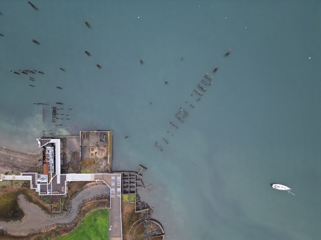
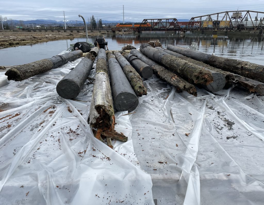
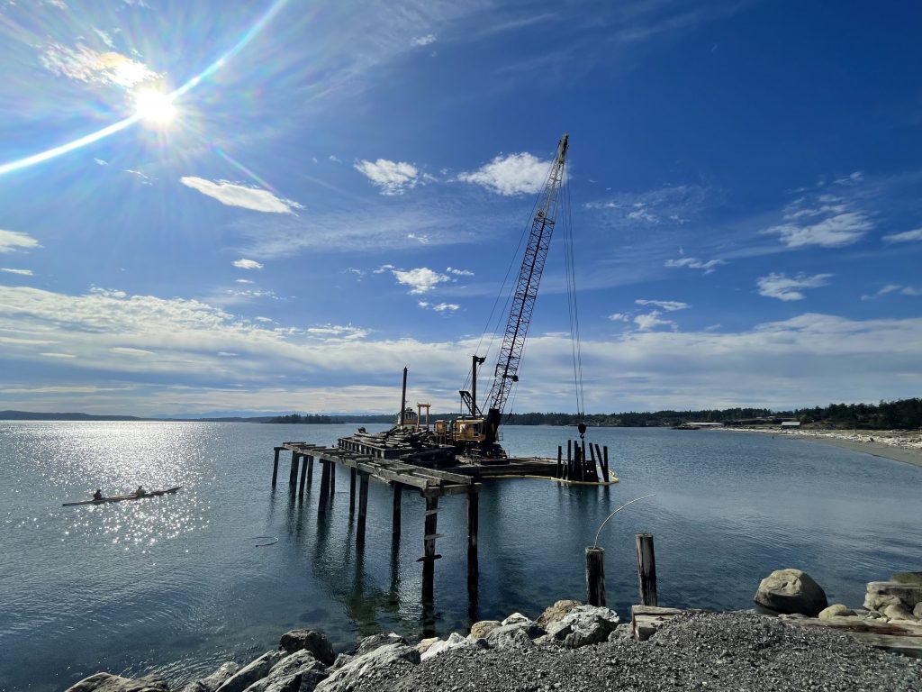
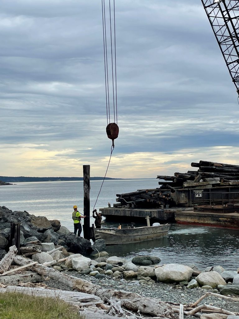
In winter 2023, DNR—along with the Snohomish Marine Resources Committee and the Tulalip Tribes—removed 290 creosote-soaked pilings from Steamboat Slough and Ebey Slough, two long side channels branching off the Snohomish River near Everett. Some of the pilings were remnants from mills and other timber operations in Marysville’s past.
The Partnership’s Nearshore Credits Program will reimburse DNR for the cost of the project with funding raised from the sale of conservation credits. This reimbursement allows DNR to free up funding for more creosote-removal projects throughout the region.
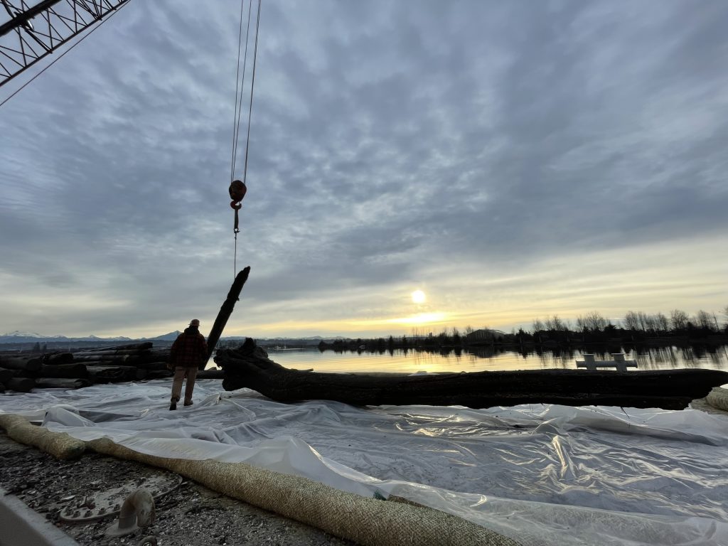
Since 2007, DNR’s Creosote Removal Program has pulled out more than 16,000 creosote-soaked pilings from Puget Sound, which translates to more than 21,000 tons of creosote removed from the nearshore environment. Creosote contains more than 300 different chemicals, and chief amongst those is a class of chemicals called polycyclic aromatic hyrdocarbons (PAHs), a known carcinogen.
“Creosote is like a low-resolution oil spill,” Robertson said. “It’s a byproduct of the coal tar process. When the sun hits creosote, it liquifies and the pilings leach it out.” Robertson mentioned that creosote can kill species through exposure and through bioaccumulation, which means that the toxic chemicals, like PAHs, can build up in tissue over time. “PAHs can get all the way up to whales,” they said, explaining how it can move through the food web. “And there’s almost 100 percent mortality for herring eggs when they’re laid on creosote pilings.” Emphasizing the toxicity of creosote-soaked pilings, Robertson mentioned that people who cut up and dispose of pilings wear personal protective equipment to safely handle the material.
Removing creosote-soaked pilings almost immediately improves the environment. Robertson explained that, with many projects, removing the pilings means removing the shade from the area, which allows for eelgrass to naturally return. Eelgrass provides key nearshore habitat for many species, including forage fish and juvenile salmon. Removing creosote-soaked structures means removing the source of contamination that could otherwise shed into the nearshore for decades.
DNR’s Creosote Removal Program estimates that there are around 15,000 creosote-soaked pilings that remain in Puget Sound, many of which are a relic of the railroad era in the Pacific Northwest. “There’s still a lot of work to do, and a big need,” said Robertson.
That’s why Robertson is optimistic about the effects of the Salish Sea Nearshore Programmatic and the Partnership’s Nearshore Credits Program. “The remaining creosote structures are large and complex projects that require multiple partners and can cost millions of dollars,” they said. “With this additional funding and the development of our Derelict Structures program we are positioned to complete the largest creosote-removal projects we have ever faced.”
Removing creosote from Jackson Beach and restoring habitat for “mighty little fish”
Jackson Beach lies on the east side of San Juan Island, about a mile and a half from Friday Harbor. For many years, Lafarge of North America operated a gravel pit near Jackson Beach and used a pier, supported by creosote-soaked pilings, to load gravel onto barges for transport. Once Lafarge’s gravel operations stopped, the company donated the land they owned to San Juan County, and San Juan County Public Works took over ownership of the shoreline parcel and the pier.
Removing the creosote-soaked pilings at Jackson Beach has been a high priority for many years. Besides being a popular destination for San Juan Island residents and visitors, Jackson Beach is adjacent to San Juan Channel, which provides habitat for surf smelt and Pacific sand lance, two key species of forage fish.
Frances Robertson, marine scientist program manager with the San Juan County Department of Environmental Stewardship, said that San Juan Channel supports an estimated 10 million Pacific sand lance, which exist in greater magnitude there than at any other place in the San Juans. With such an abundance of forage fish, Jackson Beach is also a crucial habitat area for juvenile salmon, who feed on surf smelt, Pacific sand lance, and other prey before heading out to the ocean.
San Juan County Marine Resources Committee, supported by the Northwest Straits Commission, worked with San Juan County this past fall to remove the 132 creosote-soaked pilings that supported the old pier at Jackson Beach.
The Partnership’s Nearshore Credits Program provided funding to San Juan County to reimburse the cost of the project, which was originally funded by the Northwest Straits Commission. Lucas Hart, director of the Northwest Straits Commission, believes this shows the benefits of the Partnership’s Nearshore Credits Program. “Those original funds can now be redeployed toward other Marine Resource Committee priorities that benefit the marine environment in San Juan County.” Hart mentioned that other priority work by the Marine Resource Committees includes derelict vessel removal, designating voluntary no-anchor zones to promote eelgrass growth, shoreline armor removal, outreach to crabbers, mussel monitoring, and Olympia oyster restoration, among many others. “There’s a leveraging effect that is getting additional work done in Puget Sound,” Hart said.
The work at Jackson Beach isn’t done yet. Forage fish like Pacific sand lance and surf smelt often spawn on beaches, and one way to increase spawning habitat is to remove shoreline armoring—like rock walls and bulkheads—to create a more natural beach. Robertson explained that the next phase of the restoration will involve pulling rock off Jackson Beach and creating a more naturally sloped beach to open up spawning habitat for “these mighty little fish,” as Robertson described them. “Removing the shoreline armoring will also help increase the beach’s resilience to sea level rise and erosion,” she added.
San Juan County will continue its stewardship of Jackson Beach even after the restoration is done. “Shoreline habitat is extremely important in the San Juans as feeding and rearing habitat for juvenile salmon,” said Sam Whitridge, marine program coordinator for San Juan County. “Jackson Beach is a high-priority site, given that it is a confirmed spawning beach for the forage fish species that salmon feed on. Removal of these remaining structures will greatly improve this vital habitat for forage fish species, which are essential to the success of endangered and protected species such as Chinook salmon and Southern Resident killer whales.”
Robertson was quick to point out that people can serve as stewards for their local shorelines by using DNR’s MyCoast application to report creosote-soaked debris, derelict vessels, and other nearshore hazards they may encounter on the shoreline. “I reported marine debris on a nearby beach the other day,” Robertson said. “In our area, the Samish Indian Nation has done tremendous work with DNR on creosote and debris removal. It’s important for people to do these reports on the MyCoast app.”
Union River setback levee and habitat expansion
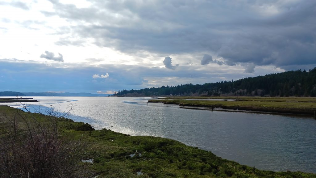
Parts of the tidal marsh near the Union River delta were diked and drained starting in the late 1800s up through the 1960s, for both farming and transportation purposes. Some of those dikes form the basis for the levees that run through the Theler Wetlands now and provide the system of trails that more than 30,000 visitors use each year to view birds and wildlife, learn more about nature, and observe the seasonal changes in the Union River, which supports one of the strongest runs of Hood Canal summer chum salmon.
“People love coming here,” said Andy Hokit, water quality and shellfish program manager with the Hood Canal Salmon Enhancement Group. “And some people have been coming here for decades. They tell us about how they remember walking the trails when they were younger, too, for school trips or outdoor education.”
During the winter of 2012, high tides damaged one of the trail system’s levees and opened up a passage between the tidal marsh and a formerly enclosed freshwater pond. After the partial breach of the levee, salmon began to use the newly accessible area, which meant that any repairs to the levee and the trail would have to account for fish passage for the salmon.
North Mason School District, which owned the land that included the pond and that section of levees, worked with the Washington State Department of Fish and Wildlife (WDFW) and the Hood Canal Salmon Enhancement Group to come up with a plan. The school district transferred the land to WDFW, and the state agency and Hood Canal Salmon Enhancement Group worked with the community to create a project that has benefits for Hood Canal summer chum salmon and preserves community access to the Union River estuary.
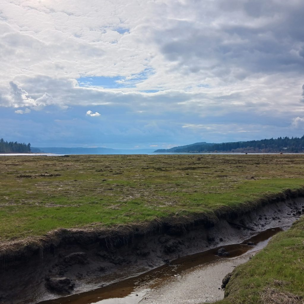
The Theler Wetlands Restoration Project will remove two levees to restore 7 acres of wetland habitat for salmon, waterfowl, and other species and build an elevated pier to fully reconnect the trail system. The project is supported in part by funding from the Partnership’s Nearshore Credits Program. Another part of the project will raise Roessel Road, which runs next to the wetlands, so that it serves as a setback levee and protects nearby residences and transportation infrastructure from occasional flooding, but also allows for more dynamic movement of the river channel.
Mendy Harlow, executive director of the Hood Canal Salmon Enhancement Group, explained that community involvement was what helped make the project such a good fit. “People are really excited,” she said. “The project doesn’t only benefit salmon, but also waterfowl and other aquatic species. The wetlands see so many visitors every year—it draws birdwatchers and people who like to walk the trails and get out into nature.”
Both Harlow and Hokit commended the nature of the Partnership’s Nearshore Credits Program and how it can help partners realize their projects. “It’s another tool in the toolbox,” Harlow said. “You have a project idea that matches up with the credit program, and all of a sudden, you receive the good news from the Partnership that you’re getting funding.”
“It’s great to have a funding program that can help you get a project over the finish line,” Hokit added.
The future of conservation credits
This year and in the near future, the Partnership’s Nearshore Credits Program will provide funding to DNR for work on the removal of four large structures: Dickman Mill in Tacoma; a pier in the Ballard neighborhood of Seattle; the former Shannon Point Seafoods pier in Anacortes; and the former High Tides Seafood pier in Neah Bay.
DNR’s work on the Dickman Mill site in Tacoma will include the removal of about 1,200 creosote-soaked pilings, and work is scheduled to start this summer. Dickman Mill was a lumber mill that operated on the shores of Commencement Bay from the 1890s until 1974. The site of the mill has been restored and turned into a park, but the ruins of the mill’s docks remain in the nearshore, a tightly grouped bank of pilings within a stone’s throw of the beach.
“Ultimately, this has the potential to drive conservation at scale around the Sound,” said Stroming.
“We still have lots of work ahead of us,” Chris Robertson said. “But with these additional resources we are now able to dramatically increase the scale and frequency of creosote removal and as a result make large steps towards Puget Sound recovery.”
“Ultimately, this has the potential to drive conservation at scale around the Sound,” said Stroming. “We see opportunities for this model to be a funding matchmaker for projects that will restore natural shoreline habitat but up until now haven’t found the resources to do it. And if it proves effective, then we have a model we can replicate in other habitat types to accelerate Puget Sound recovery.”
As Kratz, Stroming, and others have discussed, the Salish Sea Nearshore Programmatic—together with the conservation credit providers—creates a marketplace mechanism, or a kind of multiplier that can drive restoration and preserve the nearshore habitat that matters so much to the people and wildlife of Puget Sound.
